


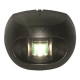
LED STERN TRANSM MNT BLK MPN-33502-7
- $69.19
$76.80- $69.19
- (-10%)
- Unit price
- per
MPN : 33502-7
SKU:
DM-207435
Availability:
Out Of Stock
Product type:
Navigation Lights
Please hurry! Only 0 left in stock
Subtotal:
$69.19
Couldn't load pickup availability


Description
xCMAPPRECCONTHD S CAROLI
Navigate the rich waters of South Carolina with the CMAPPRECCONTHD S CAROLI chart, a premium charting solution designed to enhance your fishing and boating experience. This comprehensive chart provides detailed coverage of South Carolina's diverse aquatic environments, from its scenic coastline and estuaries to its inland lakes and rivers. Whether you're a recreational angler, a seasoned professional, or a boater exploring the waterways, this chart offers the clarity and detail you need for confident navigation and successful outings.
Key Features:
- Detailed Bathymetric Data: Offers precise depth contours and underwater topography, crucial for identifying prime fishing spots, submerged structures, and safe navigation channels.
- Coastal and Inland Coverage: Provides extensive mapping for both the saltwater fishing grounds along the coast and the freshwater fisheries within South Carolina's interior.
- Fishing-Specific Information: Includes valuable data such as marked fishing areas, potential fish habitats, and points of interest that can significantly improve your catch rate.
- Easy Integration: Designed to work seamlessly with compatible Lowrance GPS and fishfinder units, ensuring a user-friendly interface and straightforward operation.
- Navigational Aids: Clearly displays buoys, markers, and other essential navigational aids to ensure safe passage and efficient travel.
- High-Definition Detail: Delivers sharp, clear imagery and data for a superior visual experience on your chartplotter.
The CMAPPRECCONTHD S CAROLI chart is an essential tool for anyone looking to maximize their time on South Carolina's waters. Its detailed bathymetry is invaluable for locating the submerged structures and drop-offs where game fish often congregate. Anglers targeting species like redfish, speckled trout, or flounder will appreciate the intricate detail of the coastal areas and inlets. Inland, the chart's coverage of lakes and rivers helps anglers find structure and understand depth changes, crucial for locating bass, crappie, and other freshwater species. The inclusion of fishing points of interest can provide a strategic advantage, highlighting areas known for productive fishing.
Beyond fishing, boaters will find the CMAPPRECCONTHD S CAROLI chart indispensable for safe and efficient navigation. The clear representation of shorelines, channels, and navigational aids allows for confident travel through busy waterways and coastal areas. This chart simplifies trip planning and provides real-time positional awareness, contributing to a more enjoyable and secure boating experience. The high-definition detail ensures that all critical information is easily visible, even in bright sunlight, allowing you to keep your focus on the water and your destination.
Product Specifications
| Specification | Value |
|---|---|
| Chart Coverage | South Carolina (Coastal and Inland) |
| Series | CMAP REVEAL |
| Compatibility | Lowrance |
| Data Type | High-Resolution Bathymetry, Fishing Points |
| Cartography | HD (High Definition) |
Related Products
Example product title
- $69.19
$76.80- $69.19
- (-10%)
- Unit price
- per
Example product title
- $69.19
$76.80- $69.19
- (-10%)
- Unit price
- per
Example product title
- $69.19
$76.80- $69.19
- (-10%)
- Unit price
- per
Example product title
- $69.19
$76.80- $69.19
- (-10%)
- Unit price
- per
Example product title
- $69.19
$76.80- $69.19
- (-10%)
- Unit price
- per
Example product title
- $69.19
$76.80- $69.19
- (-10%)
- Unit price
- per
Example product title
- $69.19
$76.80- $69.19
- (-10%)
- Unit price
- per
Example product title
- $69.19
$76.80- $69.19
- (-10%)
- Unit price
- per
Example product title
- $69.19
$76.80- $69.19
- (-10%)
- Unit price
- per
Example product title
- $69.19
$76.80- $69.19
- (-10%)
- Unit price
- per
Recently Viewed Products
Example product title
- $69.19
$76.80- $69.19
- (-10%)
- Unit price
- per
Example product title
- $69.19
$76.80- $69.19
- (-10%)
- Unit price
- per
Example product title
- $69.19
$76.80- $69.19
- (-10%)
- Unit price
- per
Example product title
- $69.19
$76.80- $69.19
- (-10%)
- Unit price
- per
Example product title
- $69.19
$76.80- $69.19
- (-10%)
- Unit price
- per
Example product title
- $69.19
$76.80- $69.19
- (-10%)
- Unit price
- per
Example product title
- $69.19
$76.80- $69.19
- (-10%)
- Unit price
- per
Example product title
- $69.19
$76.80- $69.19
- (-10%)
- Unit price
- per
Example product title
- $69.19
$76.80- $69.19
- (-10%)
- Unit price
- per
Example product title
- $69.19
$76.80- $69.19
- (-10%)
- Unit price
- per
- Choosing a selection results in a full page refresh.