




Description
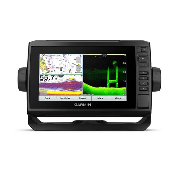
xGarmin ECHOMAP UHD 74cv Combo US BlueChart g3 with GT24 Transducer - Remanufactured
Model: 010-N2335-01- See below your boat in incredible detail with included transducer
- Navigate any waters with preloaded BlueChart® g3 coastal charts
- Share data with other devices on your network (7" and 9" models only)
- Manage your marine experience from nearly anywhere
- Control the most powerful trolling motor available
- Create your own maps on the fly and tailor them to fit your needs
The sunlight-readable 7" touchscreen chartplotter features a quick-release bail mount and a transducer for Ultra High-Definition scanning sonar and CHIRP traditional sonar.
This chartplotter supports a variety of Garmin transducers (sold separately), including the Panoptix LiveScope™ scanning sonar system, which lets you see all around your boat in real time.
This chartplotter comes with a GT24 transducer for Ultra High-Definition ClearVü scanning sonar, which shows you a crystal-clear image below your boat. Plus, you get Garmin high wide CHIRP traditional sonar for remarkable target separation.
Experience unparalleled coverage and detail with preloaded BlueChart® g3 coastal charts featuring integrated Navionics® data. Charts cover the coastal U.S., including the East and West coasts, Gulf of Mexico and the U.S. and Canadian sides of the Great Lakes.
Create personalized fishing maps on-screen with 1’ contours. Keep the data to yourself, or share it with the Quickdraw Community on Garmin Connect™.
If you have multiple compatible ECHOMAP UHD or ECHOMAP Ultra devices on your boat, you can share information — such as sonar, user data and charts — among them (7" and 9" models only).
Connect to autopilots, digital switching, weather, FUSION-Link™ audio system, media, VHF, AIS and more from one screen.
Built-in Wi-Fi® connectivity pairs with the free all-in-one mobile app for access to the OneChart™ feature, smart notifications1, software updates, Garmin Quickdraw™ Community data and more.
Take control of the most powerful and efficient trolling motor available2, route it to waypoints, follow tracks and more from the screen of your chartplotter.
Specifications| General | Physical dimensions |
|---|---|
| 9.8" x 5.5" x 2.0" (25 x 13.9 x 5.1 cm) | Display size |
| 6.1" x 3.4"; 7.0" diagonal (15.5 x 8.6 cm; 17.8 cm diagonal) | Display resolution |
| 400 x 800 pixels | Display type |
| WVGA display | Weight |
| 1.7 lbs.(0.77kg) | Water Rating |
| IPX7 | Power consumption |
| 15W | Antenna |
| Internal or external over NMEA 2000 | Mounting options |
| Bail or flush | Receiver |
| 5 Hz | Garmin Marine Network™ ports |
| 1 Panoptix™ port | Maps & Memory |
| Preloaded maps | BlueChart® g3 (coastal maps) |
| Accepts data cards | 1 microSD™ card; 32 GB maximum size |
| Waypoints | 5,000 |
| Routes | 100 |
| Track log | 50,000 points; 50 saved tracks |
| Outdoor Recreation Features | Tide tables |
| Yes | Chartplotter Features |
| Garmin Sonar compatible | Yes |
| Supports AIS (tracks target ships position) | Yes |
| Supports DSC (displays position data from DSC-capable VHF radio) | Yes |
| GCV™ Black Box sonar support | Yes |
| ActiveCaptain compatible | Yes |
| Sailing Features | Yes |
| Sonar Features & Specifications | Dual-frequency (50/200 kHz) sonar capable |
| Yes | Dual-beam (77/200 kHz) sonar capable |
| Yes | Transmit power |
| 500 W (RMS) / 4,000 W (peak to peak) | CHIRP sonar technology |
| Yes (Built-in) | ClearVü |
| Yes with CHIRP (built-in) | SideVü |
| No | Maximum depth |
| 2,300 ft @ 77 kHz, freshwater | Bottom lock (shows return from the bottom up) |
| Yes | Water temperature log and graph |
| Yes | Sonar recording |
| Yes | Sonar history rewind |
| Yes | Connections |
| NMEA 2000® compatible | Yes |
| Transducer pin numbers | 8 |
| NMEA 0183 input ports | 1 |
| NMEA 0183 output ports | 1 |
| Video input ports | None |
| Video output ports | None |
| Wireless connectivity | Yes |
What's in the Box:
- ECHOMAP UHD 74cv with BlueChart Offshore g3 for U.S. - Remanufactured
- GT24UHD-TM transducer
- Power/data cable
- Tilt/swivel mount with quick release cradle
- Flush mount
- Protective cover
- Hardware
- Documentation
- Choosing a selection results in a full page refresh.